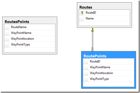
Not long ago I had a mission to normalize a Routes Waypoint table .
The current RoutePoints table should be split into 2 tables:Route table and a Waypoints table.
IF EXISTS ( SELECT *
    FROM sys.tables
    WHERE name = 'RoutesPoints' )
   DROP TABLE RoutesPoints;

CREATE TABLE RoutesPoints
   ( RouteName VARCHAR(255),
      WayPointName VARCHAR(255),
      WayPointlocation GEOGRAPHY ,
      WayPointType VARCHAR(6),
   );
INSERT INTO RoutesPoints
   (  RouteName, WayPointName,WayPointlocation, WayPointType )
VALUES
(  'Route1', 'WayPoint1', geography::STGeomFromText('POINT(32.34900 36.65150)', 4326) , 'Start' ),
(  'Route2', 'WayPoint2', geography::STGeomFromText('POINT(32.34900 36.65260)', 4326) , 'Start' ),
(  'Route1', 'WayPoint3', geography::STGeomFromText('POINT(32.34900 36.65600)', 4326) , 'Middle' ),
(  'Route3', 'WayPoint4', geography::STGeomFromText('POINT(32.34900 36.65666)', 4326) , 'End' ),
(  'Route3', 'WayPoint5', geography::STGeomFromText('POINT(32.34800 36.65160)', 4326) , 'Middle' ),
(  'Route2', 'WayPoint6', geography::STGeomFromText('POINT(32.34980 36.65290)', 4326) , 'Start' ),
(  'Route1', 'WayPoint7', geography::STGeomFromText('POINT(32.34908 36.61100)', 4326) , 'Start' ),
(  'Route2', 'WayPoint8', geography::STGeomFromText('POINT(32.34950 36.65150)', 4326) , 'Middle' ),
(  'Route1', 'WayPoint9', geography::STGeomFromText('POINT(32.34900 36.65540)', 4326) , 'Start' ),
(  'Route2', 'WayPoint10', geography::STGeomFromText('POINT(32.34900 36.65550)', 4326) , 'Start' ),
(  'Route1', 'WayPoint11', geography::STGeomFromText('POINT(32.34900 36.65230)', 4326) , 'End' ),
(  'Route2', 'WayPoint12', geography::STGeomFromText('POINT(32.34940 36.65150)', 4326) , 'Middle' ),
(  'Route1', 'WayPoint13', geography::STGeomFromText('POINT(32.34600 36.65270)', 4326) , 'Start' ),
(  'Route4', 'WayPoint16', geography::STGeomFromText('POINT(32.34500 36.65340)', 4326) , 'Start' ),
(  'Route1', 'WayPoint14', geography::STGeomFromText('POINT(32.34500 36.65160)', 4326) , 'Middle' ),
(  'Route2', 'WayPoint17', geography::STGeomFromText('POINT(32.34400 36.65150)', 4326) , 'Middle' ),
(  'Route3', 'WayPoint18', geography::STGeomFromText('POINT(32.34200 36.65140)', 4326) , 'Start' ),
(  'Route3', 'WayPoint19', geography::STGeomFromText('POINT(32.34200 36.65150)', 4326) , 'Start' ),
(  'Route1', 'WayPoint20', geography::STGeomFromText('POINT(32.34100 36.65140)', 4326) , 'Middle' ),
(  'Route2', 'WayPoint21', geography::STGeomFromText('POINT(32.34100 36.65150)', 4326) , 'End' ),
(  'Route1', 'WayPoint22', geography::STGeomFromText('POINT(32.34910 36.65160)', 4326) , 'Middle' ),
(  'Route2', 'WayPoint23', geography::STGeomFromText('POINT(32.34430 36.65100)', 4326) , 'Start' ),
(  'Route2', 'WayPoint24', geography::STGeomFromText('POINT(32.34440 36.65180)', 4326) , 'Start' ),
(  'Route2', 'WayPoint25', geography::STGeomFromText('POINT(32.34530 36.65140)', 4326) , 'Middle' ),
(  'Route1', 'WayPoint26', geography::STGeomFromText('POINT(32.34340 36.65800)', 4326) , 'Start' ),
(  'Route3', 'WayPoint27', geography::STGeomFromText('POINT(32.34670 36.65700)', 4326) , 'Start' ),
(  'Route2', 'WayPoint28', geography::STGeomFromText('POINT(32.34540 36.65600)', 4326) , 'End' ),
(  'Route3', 'WayPoint29', geography::STGeomFromText('POINT(32.34650 36.65500)', 4326) , 'Middle' ),
(  'Route1', 'WayPoint30', geography::STGeomFromText('POINT(32.34345 36.65140)', 4326) , 'Start' ),
(  'Route4', 'WayPoint31', geography::STGeomFromText('POINT(32.34584 36.65130)', 4326) , 'Start' ),
(  'Route5', 'WayPoint31', geography::STGeomFromText('POINT(32.34888 36.65200)', 4326) , 'Middle' ),
(  'Route4', 'WayPoint32', geography::STGeomFromText('POINT(32.34900 36.65100)', 4326) , 'Middle' )